| The Arctic: Larger than Words and Irreplaceable | |
| By Diane Gayer | |
 |
|
| A brilliant display at sunrise as light reflects off the ice at Prince Leopold Island - Photos by Diane Gayer | |
| How do I begin to describe a place so vast, so unimaginable, so other? Like most everyone, I had heard about the Arctic’s melting polar ice cap, new attempts there to drill for oil and gas, and plans to keep shipping lanes open year round. But I hadn’t yet witnessed the Arctic’s fragility, its uniqueness, or its beauty.
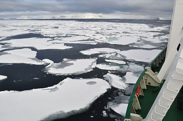
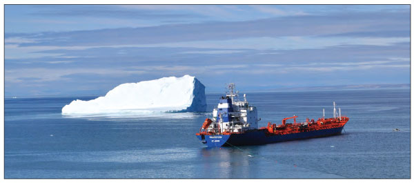
This past August, Mary Twitchell and I flew from Ottawa to Kangerlussuaq, Greenland, where we boarded a former Russian military vessel, now being used as a research vessel and offering tours of the Northwest Passage. The vastness we traveled through eludes description. At times land seemed to be layers of fog, and at other moments, appeared as bands of light on the horizon. The landscape was elusive and mesmerizing, yet earthy with the everyday grit of life, and wild changeling weather. This expanse of light and quiet was inhabited by the Inuit in Nunavut, the northernmost province of Canada; by Greenlandic people; by the Sami in Norway, and by many other peoples across Siberia. Each group has found ways to live within its climate, but now each is faced with “southerners” moving in to build roads, schools, clinics, mines, and to explore for gas and oil. Leaving Greenland, we sailed up Baffin Bay towards Lancaster Sound, and spotted an amazingly brilliant piece of ice in the distance. As we approached, we discovered what is known as “tabular ice.” The particular island of ice we saw was about a mile and a quarter long. It was thought to have broken away from the Petermann Glacier in northwest Greenland. Many of these events are now videoed, and the resulting research made available through the web. But the reality is very different. Seeing such tabular ice floating slowly toward Labrador left me in awe, yet words don't describe what I felt, seeing it. Not long ago a voyage like ours was full of danger—whether on a working vessel like whaling ships, or on earlier expeditions, such as that of Capt. John Franklin. Franklin was an English explorer bent on crossing the Northwest Passage. In his third attempt in 1845, he set out beyond “known territory” with the HMS Erebus and HMS Terror. He and his 128 men perished. We followed their route. When we stopped at Beechey Island, Franklin’s first winter camp, we used the zodiacs to go ashore in evening light and snow squalls. The ghosts of those who had died on this colorless, rocky headland blew around us in the snow. The arctic light filtered our thoughts of men, remembered more for dying, than for any observations or insights they might have contributed. If there is something to be learned from their “failed” expedition, perhaps it is that survival in the long run is always dependent on understanding local conditions. So, I ask the question: Can we still discover the Arctic as a vibrant and wild ecosystem? Can we learn to see the complexity of life it takes for survival? Can we learn from the ice, the krill, the polar bear, the seals, the fishes, the birds and the people who have long lived there, and before it is too late? Before leaving Lancaster Sound, we visited the Royal Canadian Mounted Police (RCMP) site on Devon Island. I kayaked into the small cove, watching the fog lift and shift over the island outcrops. The icebergs floated and calved, a word describing the chunks that break off. A polar bear slowly shuffled across the tundra-clad hills. The RCMP outpost was maintained only from 1922 to 1929. The last of the young men assigned here for two-year stretches had died; one committed suicide, and the other died of a gun-shot wound. They were both buried under rocks overlooking the small bay. The now unstaffed cabin still has jars of unused peanut butter; Artic poppies bloom in the doorway. But dispute over this watery zone, sometimes known as the Canadian Internal Waters, with its 36,563 islands, continues. As the ice melts, national interests grow. Disputes over ownership of shipping lanes, gas and oil drilling access, and mineral rights threaten the region.
With exploration and development comes a push for year-round shipping routes, despite the fact that ice cover remains critical to movement for humans and other animals. Inuit hunting for seal and whale is an ice-based activity; we saw the sledges and dogs everywhere, waiting for winter to arrive. The ice, and living with the ice, has been vital to survival. The complex system that formed in this climate is somewhat invisible to us southerners—in part because it occurs under the ice, but more because we don’t have the patience or skill to really look. Waiting is a way of life here—from the polar bear that hopes for the seal to come out of his hole in the ice; to the hunter who sits ready to spear the narwhale; to the co-op manager who prays for shipments of produce, clothing, snow machines, bicycles, and more to arrive. Our vessel had been following the movement of two-year pack ice via satellite imagery. Pack ice had been moving around, owing to storms, and drifting or packing in at the mouth of Bellots Strait, our intended route from Lancaster Sound to Cambridge Bay on Victoria Island. Pack or drift ice forms from seawater, and can solidify into impenetrable masses. You might follow an open lead in the water, only to end up with the ice pressure closing in around you from behind. As there are a number of northwest passages through this archipelago, it has been easy for expeditions to get lost, and subsequently stuck in a frozen sea. We learned that a Canadian Coast Guard icebreaker, the Henry Larsen, would escort us through Bellot Strait. So our ship, the Akademik Ioffe, took off with the current, moving through the icy narrows by following the icebreaker. We had thought we were alone out there—us and the pack ice, the bearded seals, the polar bear cubs following their mother through the sea of ice, and musk oxen blending into the headland. But suddenly, rafting up with us were the Queen MII, a high-end private yacht, a double-hull ship, and two single-hull sailboats. In addition, a red and white helicopter from the Henry Larsen acted as scout as we passed Zenith Point, the northernmost tip of the North American continent. Cultures have vocabularies to describe the conditions that make up their lives. The classic example is the Inuit languages with their many words for snow. But what I want to know is, who has the language for the many kinds of water I saw? What is the name for glaciers that calve and whose pieces get caught in a narrow fjord causing an icy traffic jam? Or the turquoise blue liquid that surrounds the edge of an iceberg? Or the silty-salty line where tidal water meets fresh, clear fjord water? Is this something we have yet to name? Is this something we are going to need to know as the melting glaciers transform our own way of life? What about a word for the rising flood waters we experienced on Lake Champlain in 2011? Or the raging waters of Tropical Storm Irene in Vermont?
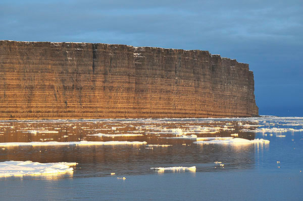
The arctic is not without sound. Arriving at Prince Leopold Island, it was not daybreak that awakened us, it was the crying of baby murres. This island, a steep-sided bluff that glowed at dawn like a jeweled crown surrounded by a sea of golden icebergs, is known for its breeding colony of thick-billed murres. They are members of the auk family, and cousin to the puffin. But it was their racket that drew us outside onto the bridge. We heard the baby murres in the water, wingless, and paddling as best they could. They had left their nests on the high cliffs, pushed out or jumping during cover of night. The papa murres were busily swimming, trying to find their offspring amid the floating ice. We followed the screeching babies, and watched as the fathers reunited with their young, and stashed them on their backs. While both parents care for the young on the cliffs, it is the male who takes them for the long swim to southern Greenland, fishing and feeding along the way. Finally we sailed through storms and heavy seas to arrive in Cambridge Bay, on Victoria Island, in Nunavut Province. The Inuit name for this place is Iqaluktuttiaq, meaning "good fishing place.” But this town’s future is changing from traditional hunting and fishing grounds to being the location of Canada's new High Arctic Research Station (CHARS). According to Canadian Prime Minister Stephen Harper’s 2010 announcement, the development of the station, owing to its key location along the Northwest Passage, is to be an integral part of Canada's Northern Strategy. “It will serve political purposes, such as asserting Canada's sovereignty in the high north.” Government research stations are not necessarily neutral. They are the first steps in exploration and, over time, they have a colonizing effect. Stations import what they need, and have little relationship to the local conditions. Walking around Cambridge Bay it was easy to find a new high-tech building under construction. It looked especially shocking in its glass skin, compared to older plywood buildings, and more recent prefab structures. What I cannot comprehend is the willingness of nations and corporations to destroy this land’s immense beauty for gas and oil, copper, and gold. Yes, there may be a desire for a cash economy in the Arctic. Yes, nations may need more fuel for producing goods and services in the temperate zones. But it all comes at a cost. And the cost can be too high. We flew home with several stops. First came Kugluktuk, formerly Coppermine, the Hudson Bay Company’s first interior trading post on the border of Northwest Territories and Nunavut. We stood on rock, covered in short stubby tundra vegetation, looked out across Coronation Gulf, and wondered at this thing men had sought, called the Northwest Passage. Our second stop was Yellowknife, capital of Canada's Northwest Territories. This is where we disembarked to go through our first airport security check, so that we could fly on down to Edmonton where we stayed overnight. By the time we got to Ottawa the following day, we had begun to feel how very far away we had been. Back in Vermont, I struggled with the question, “How was your trip?” How was the Arctic?” I do not know how to answer this. How can I compare the life that is so linked to climate with our own lives? We are domesticated with our climate-controlled buildings and homes, with roads and highways, with food stores and restaurants. Unless there is a hurricane or flood, fire or earthquake, we are surprised that weather has any impact at all on our daily life. In Burlington time seems safe, sound, and contained by daily activities. It sits still, unchallenged. But time in the Arctic was mind-bendingly alive: Night and day were intertwined, six time zones came and went in so many days, and the deep history of ice surrounded us. Past, present, and future were all visible and real at once, not separated by units of time or our linear progression along an imaginary line. Something shifted in my being during those two weeks in the Arctic. But when was that moment? When was it that the sky and sea took over, and we lost the inherent meaning of trees, boulevards of buildings, and city lights? Was it when we saw the musk ox as little wooly specs in the landscape? Or when the polar bear with two little ones jumped from one ice floe to the next in this icy realm? Or was it when we watched the pods of pilot whales fishing the herring up Baffin Bay? I cannot resolve the conflicts arising in the Arctic. I can barely understand the irony of our own travel to witness what might be lost forever. Richness does not come from oil and gas revenues, but from that one moment of communion when the humpback whales breach and play. There must be a way for the sacred to survive in our world.
|
|
|
Diane Elliott Gayer, director of the Vermont Design Institute, is a licensed architect, specializing in ecological and community design, and adjunct faculty at The University of Vermont.
|